

Map Zone Delimiter
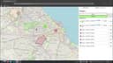
I developed Map Zone Delimiter because I needed a versatile tool to assign geospatial data in different ways, as the existing solutions didn't fully meet my requirements. The application supports zone management through adjustable radius, polyline areas, and abstract areas with Voronoi diagrams. It also includes CSV import/export, point and group management, and an interactive map-based interface for working with structured location data.

Implemented technologies

Process and challenges
Firstly, I laid the foundation by adding a map using the Leaflet library. I implemented basic functions to add points on the map through clicks, ensuring an initial visualization of the locations.
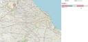
Next, I added the functionality to group points. This allowed organizing points into different groups, facilitating the management and classification of locations on the map.
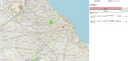
Then, I incorporated additional features for points, such as the ability to delete or identify them. This enhanced the interaction with points, allowing for more detailed and precise management.
I introduced the functionality to create polyline areas, enabling the delimitation of zones by connecting points with lines. This provided a more versatile way to define geospatial areas on the map.
Subsequently, I added the capability to create radius zones, where points are surrounded by an adjustable circle. I implemented range controls to dynamically modify the radius of these circles, enhancing flexibility in area delimitation.
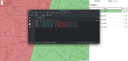
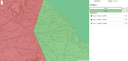
Finally, I integrated dynamic zones using Voronoi diagrams. This allowed segmenting the map into abstract areas based on point distribution, facilitating more precise data assignment to the nearest zones.
Technical Decisions
Voronoi diagrams for abstract zones
Added Voronoi-diagram-based zones to segment the map into abstract areas based on point distribution, enabling more precise nearest-zone assignment.
Current Status
ArchivedConclusion and next steps
Future improvements could include more dynamic point administration features, such as enhanced visual grouping and reordering of points in the list. Additionally, optimizing the application for mobile support would significantly broaden its usability.